

You can find on this page the Kiev neighborhood map to print and to download in PDF. The Kiev districts map presents quarters, region, suburbs and surrounding area of Kiev in Ukraine.

The Kiev districts map shows all quarters and suburbs of Kiev. This district map of Kiev will allow you to discover areas and the region of Kiev in Ukraine. The Kiev districts map is downloadable in PDF, printable and free.
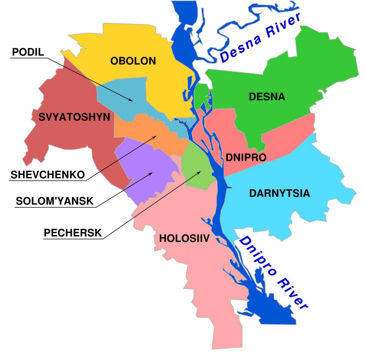
Subdivisions of Kiev, the capital of Ukraine, include the formal administrative subdivision into raions and the more detailed informal subdivision into historical neighborhoods. Administratively, the city is divided into "raions" ("districts"), which have their own locally elected governments with jurisdiction over a limited scope of affairs. Presently, there are 10 raions as you can see in Kiev districts map. Right-bank districts: Holosiivskyi Raion, Obolonskyi Raion, Pecherskyi Raion, Podilskyi Raion, Shevchenkivskyi Raion, Solomianskyi Raion, Sviatoshynskyi Raion. Left-bank districts: Darnytskyi Raion, Desnianskyi Raion, Dniprovskyi Raion. Most of the raions are named after respective historical neighborhoods of the city.
The first known formal subdivision of Kiev dates to 1810 when the city was subdivided into 4 parts: Pechersk, Starokyiv, and the first and the second parts of Podil. In 1833-1834 according to Tsar Nicholas I decree, Kiev was subdivided into 6 police raions; later being increased to 10. As of 1917, there were 8 Raion Councils (Duma), which were reorganized by Pavlo Skoropadskyi into 17 raions. In 1924 bolsheviks reorganized them into the bigger six party-administrated Raions with various sub-raions under Hryhoriy Hrynko administration. All the city modern raions that start with a letter D are located on the left bank of Dnieper as its mentioned in Kiev districts map and until 1927 were part of Chernigov Governorate with Darnytsia being the first to be incorporated within the city limits that year. Over the Soviet time, as city was expanding, the number of raions was gradually increasing. The raions has been also commonly named after Soviet party leaders, and as political situation was changing and some leaders were overturned by the other, so raion names were also changing. The last raion reform took place in 2001 when the number of raions has been decreased from 14 to 10.
Former Raions as its shown in Kiev districts map: Zaliznychny (April 9, 1938 - October 2001), most of it became the Solomianka Raion. Zhovtnevy (~1920 - October 2001), raion was created on the territory of Shuliavka that became famous for the Uprising of 1905, in 1938 khutor Vidradny was incorporated within the raion, later became the Solomianka Raion. Minsk ( March 3, 1975), renamed into Obolon Raion. Starokyiv ( - October 2001), merged with Sovietsky to form Shevchenko Raion. Sovietsky ( - October 2001), merged with Starokyiv to form Shevchenko Raion. Leningrad (April 12, 1973 - October 2001), formed out parts of Zhovtnevy, Sovietsky, and Shevchenko, later renamed into Sviatoshyn Raion. Shevchenko (prior to 2001). Rakhiv-Sviatoshyn (January 1924 - April 1973), included Sviatoshyn sub-raion, later became Leningrad. Sviatoshyn (1918 - 1924), created by an administrative reform of Pavlo Skoropadskyi, was incorporated as a sub-raion into Rakhiv-Sviatoshyn. Moscow (1921 - October 2001), reorganized as Holosiiv Raion. Kharkiv ( 2004), became part of Darnytsia Raion.