

You can find on this page the Kiev tram map to print and to download in PDF. The Kiev trams map presents the network, zones, stations and different lines of the tramway of Kiev in Ukraine.
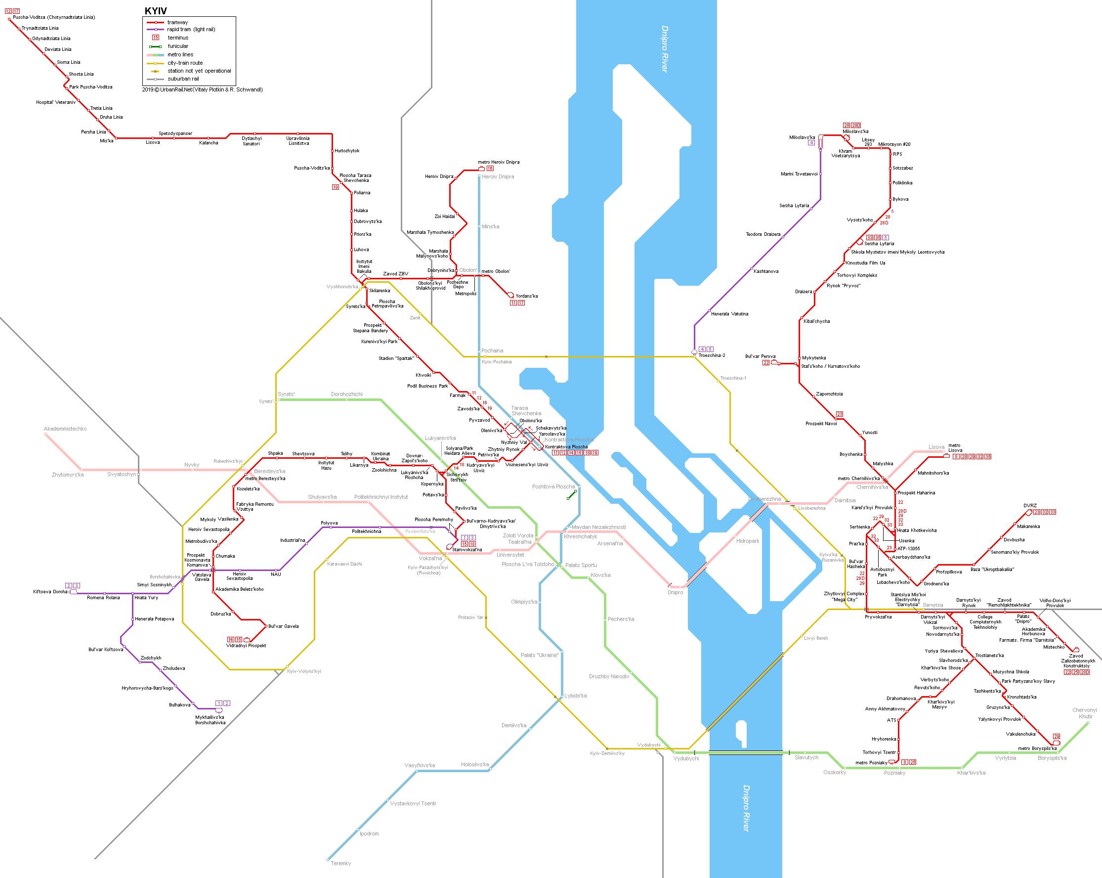
The Kiev tram map shows all the stations and lines of the Kiev tramways. This tramway map of Kiev will allow you to easily plan your routes in the trams of Kiev in Ukraine. The Kiev tram map is downloadable in PDF, printable and free.
The Kiev tram (Ukrainian: Київський трамвай, translit.: Kyivs’kyi tramvai), which serves the Ukrainian capital city of Kiev, was the first electric tramway in the former Russian Empire (modern-day Ukraine) and the third one in Europe after the Berlin Straßenbahn (tram) and the Budapest tramway. The system currently consists of 139.9 km of track, including 14 km of the first 2 light rail lines, which were opened in 1978 as its shown in Kiev tram map. However, the serviced track length is decreasing at a fast rate and is replaced by buses and trolleybuses. Apart from the standard tram system, there is a rapid tram line, which runs from the Railway Station (Vokzal'na) to the western suburbs (Kil'tseva Doroha, 9.1 km, 1977). Running in the median of a major road, after 20 years of operation, the line was upgraded in 2009/2010.
Tram routes are functioning on both banks of Kiev city. But the rails of the tram lines are not interconnected, i.e. there is no route that allows you to reach from the left bank of the Dnipro river to the right bank and vice versa. Kiev tram system is mainly concentrated in the sleeping areas of Kiev and small sections of tram tracks are located closer to the central part of the capital of Ukraine. The main routes are functioning to eliminate the extra load to the other kinds of public transport in districts, where the subway does not function and to help people quickly get to the nearest metro station. The Kiev tram system uses many different tram cars and types, with some being designed in Moscow and manufactured in Riga, some being manufactured by the ČKD Tatra company in Prague, and with some being manufactured right in the city of Kiev as you can see in Kiev tram map.
Those Kiev trams, which go in the morning in the direction of a subway, start working at 5.40 a.m as its mentioned in Kiev tram map. Their last route they usually perform at 24.00 at night. The interval between trams is, on average, 5-10 minutes and it can vary depending on the situation on Kyiv roads, weather conditions, time of day and number of the route. Time of the stop at the station is, approximately, 15-30 seconds. A branch to Mikhailsvs'ka Borschahivska, which has a more light rail type alignment, was added in 1984. A second 5.2 km rapid tram line was built between 1993 and 2000, running from Prospekt H. Vatutina station to Vulytsia Miloslavskaya station in the district of Troeschina in the north of the left bank. Not properly connected to any other rapid transit line, it was taken out-of-service in 2009, but re-opened after some upgrades on 25 Oct 2012 along with a 1.5 km extension to Troeschina-2, a new station on the city ring railway. Line 4, which runs exclusively on the rapid tram section, has a length of 6.7 km.